
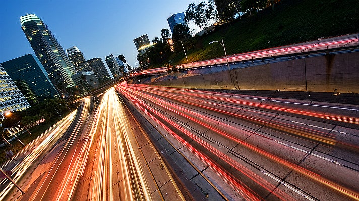

The City of Los Angeles is served by an extensive network of freeways, streets, and local and regional public transportation systems. A dozen major freeways that span hundreds of miles connect the various regions of L.A.
When locals give directions, they usually refer to a freeway only by its number and the word “the,” e.g. "Take the 405 to the 10" instead of “Take the San Diego Freeway to the Santa Monica Freeway.” However, local radio station traffic reports often refer to freeways by their names, such as the San Diego Freeway and the Santa Monica Freeway instead of the 405 and 10, respectively.
Here are some freeway interchanges that are frequently mentioned in traffic reports:
- "Four Level Interchange" (Bill Keene Memorial Interchange) is the intersection of the 110 and 101 Freeways in Downtown L.A.
- "East L.A. Interchange" is the junction of the 5, 10, 101 and 60 freeways just southeast of Downtown L.A.
- "Hollywood Split" is the intersection of the 101,134 and 170 freeways in North Hollywood.
Read on for a guide to L.A. freeways, including points of interest and insider tips on alternate routes.
For more info about basic driving rules, parking, scenic drives and more, visit our Guide to Driving in Los Angeles.
I-405
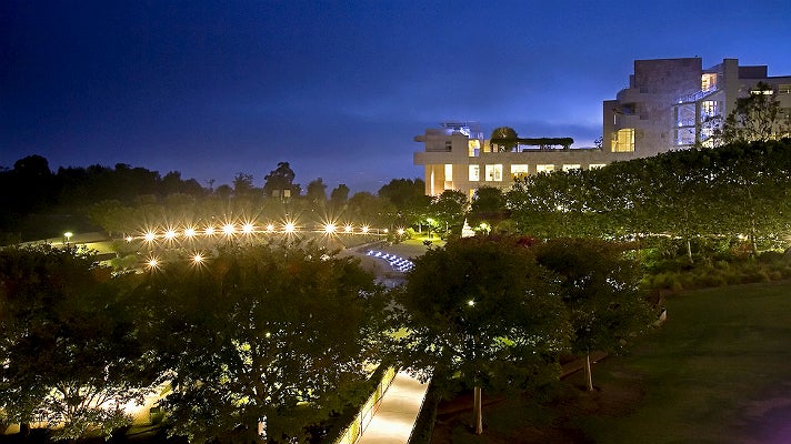
Interstate 405 aka the San Diego Freeway is the main north/south freeway for the Westside of L.A. and roughly follows the outline of the Pacific coast for much of its route. The 405 is one of the busiest freeways in the country, the most commonly used highway to LAX, and a bypass for Interstate 5. The 405’s northern terminus is the 5 in the San Fernando Valley. It runs south from the Valley, travels through the Westside and continues south from LAX towards Long Beach, then turns east and merges with the 5 again in Orange County.
Points of interest: CSUN, Japanese Garden at Woodley Park, Mulholland Drive, Getty Center, Skirball Cultural Center, UCLA, Hammer Museum, Century City, Beverly Hills, Little Osaka, Culver City, StubHub Center
Alternate north/south streets: Sepulveda Boulevard, La Cienega Boulevard, “the canyons” (e.g. Beverly Glen, Benedict Canyon, Laurel Canyon)
I-10

Interstate 10 aka the Santa Monica Freeway/San Bernardino Freeway is the main east/west freeway connecting Downtown L.A. and Santa Monica. Formally named the "Christopher Columbus Transcontinental Highway" in Santa Monica, Interstate 10 travels east from L.A. all the way through Phoenix, Houston and New Orleans to Jacksonville, Florida. The Santa Monica Freeway is the westernmost segment of Interstate 10, beginning at the western terminus of I-10 at the Pacific Coast Highway in Santa Monica and ending southeast of Downtown L.A. at the East Los Angeles Interchange, which connects the I-10, I-5, SR 60 and US 101 freeways. From Downtown L.A. the 10 is known as the San Bernardino Freeway and heads east from the San Gabriel Valley into San Bernardino County. Along with the 60, the 10 is the main route from L.A. to Riverside County and Palm Springs.
Points of Interest: Santa Monica Pier, Santa Monica Place, Bergamot Station, Sony Pictures Studios, Helms Bakery, Restaurant Row, Museum Row, Wiltern Theatre, Koreatown, Downtown L.A., FIDM, Arts District, Cal State L.A., Monterey Park, Alhambra, Fairplex
Alternate east/west streets: Washington Boulevard, Venice Boulevard, Pico Boulevard, Olympic Boulevard, 6th Street, Valley Boulevard
SR 60
State Route 60 aka the Pomona Freeway runs parallel to the 10 from Downtown L.A. Its western terminus is the East L.A. Interchange and it travels through the south side of the San Gabriel Valley before its eastern terminus at the 10 in Riverside.
Points of interest: Boyle Heights, Whittier Narrows Recreation Area, Ontario Airport
I-105
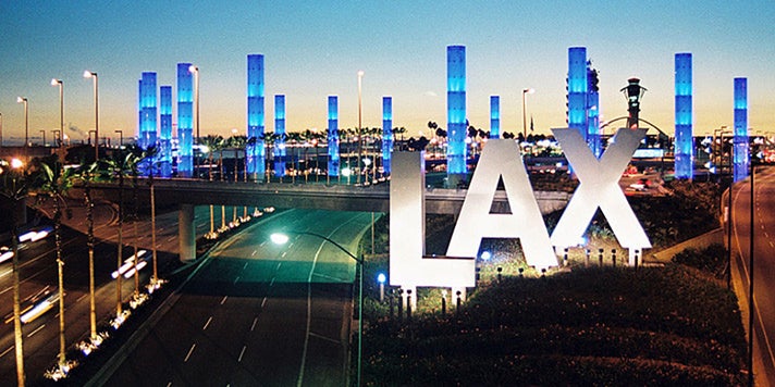
Interstate 105 aka the Glenn Anderson Freeway or the Century Freeway is an east/west highway that runs several miles south and parallel to the 10. The 105 is a key route to and from LAX. The 105 begins on its western end at Sepulveda Boulevard on the south side of of LAX and terminates to the east at the 605.
Points of interest: LAX, Watts Community Labor Action Committee
US 101

U.S. Route 101 aka the Hollywood Freeway/Ventura Freeway is the longest highway in California and is the major coastal north–south route that links Los Angeles to the Central Coast, the San Francisco Bay Area and the North Coast (Redwood Empire). The south terminus of the 101 is the East L.A. Interchange near Downtown L.A. The 101 runs northwest from Downtown L.A. as the Hollywood Freeway and continues through Hollywood and into the San Fernando Valley, where it intersects with the 134 and 170 freeways at the “Hollywood Split.” From there, the 101 becomes the Ventura Freeway and turns west through the Valley. The 101 continues to the Central Coast through Santa Barbara, San Luis Obispo, the San Francisco Bay Area, Oregon, and ends in Washington. From the Hollywood Split, the 170 continues northwest and terminates at the northbound I-5. NOTE: depending on the stretch of the east-west Ventura Freeway, the freeway signs will alternately say the “101 North” or “101 West,” and “101 South” or “101 “East.” Visitors are sometimes confused because there is no accompanying interchange or border to indicate the sign switch.
Points of Interest: Universal Studios Hollywood, Universal CityWalk, Hollywood Bowl, Runyon Canyon, Hollywood Sign, Hollywood & Highland, TCL Chinese Theatre, Dolby Theatre, Walk of Fame, Hollywood Museum, Amoeba Records, Sunset Strip, West Hollywood, Koreatown, Grand Park, City Hall, Little Tokyo, Union Station, Olvera Street, Chinatown
Alternate east/west streets: Moorpark Street, Riverside Drive, Ventura Boulevard, Cahuenga Boulevard, Franklin Avenue
SR 134
State Route 134 aka the Ventura Freeway runs east from the Hollywood Split through Burbank, Glendale and Eagle Rock and terminates at the 210 in Pasadena. NOTE: There is no interchange from the 134 West to the 101 South.
Points of interest: Warner Bros. Studios, Los Angeles Equestrian Center, Norton Simon Museum, Rose Bowl Stadium, Kidspace Museum
Route 210 (I-210 & SR 210)

Route 210 aka the Foothill Freeway is a bypass Interstate (I-210) that runs southeast from the 5 in the Valley and connects with the 134 in Pasadena. From there, it turns east towards Glendora, where it becomes State Route 210 (SR 210) and terminates at the 10 in Redlands.
Points of interest: Hansen Dam Recreation Center, Jet Propulsion Laboratory, Pasadena Playhouse, Cal Tech, L.A. County Arboretum, Santa Anita Park, Raging Waters
I-5

Interstate 5 aka the Golden State Freeway/Santa Ana Freeway is the main north/south freeway through Central Los Angeles. I-5 links major California cities like L.A., San Diego and Sacramento. The highway's southern terminus is the U.S.-Mexico border in California and its northern terminus is the U.S.-Canada border in Washington. It’s the only Interstate highway to touch the U.S. borders with both Canada and Mexico. The 5 enters L.A. County from the north as the Golden State Freeway, runs through the eastern San Fernando Valley, and continues south from the East L.A. Interchange as the Santa Ana Freeway.
Points of interest: Six Flags Magic Mountain, Burbank Airport, Griffith Park, Los Angeles Zoo, Autry National Center, Los Angeles River, Griffith Observatory, Los Feliz, Citadel Outlets
SR 2
State Route 2 is a state highway that runs from the junction of Lincoln Boulevard and the 10 in Santa Monica to SR 138 east of Wrightwood. The western end of the 2 is an old section of the legendary Route 66, while the eastern end is known as the Angeles Crest Highway. The section of the 2 known as the Glendale Freeway begins just north of Downtown L.A. near Dodger Stadium and terminates at the 210 in La Canada Flintridge. From there, SR 2 continues into the Angeles National Forest.
Points of interest: Silver Lake, Forest Lawn, Eagle Rock, Descanso Gardens, Angeles National Forest, Mountain High
Route 110 (I-110 & SR 110)

Route 110 aka the Arroyo Seco Parkway/Harbor Freeway is a state highway that runs north/south from Pasadena through Downtown L.A. to San Pedro and the Port of Los Angeles. The 110 is an Interstate (I-110) south of the 10, and a State Route (SR 110) north of the 101. The northern section of the 110 to Pasadena is the historic Arroyo Seco Parkway (formerly Pasadena Freeway), the first freeway in the western United States. South of the 101, the 110 is known as the Harbor Freeway.
Points of interest: The Huntington Library, Highland Park, Dodger Stadium, Walt Disney Concert Hall, L.A. LIVE, STAPLES Center, Los Angeles Convention Center, Exposition Park, USC, Watts Towers, Battleship IOWA, Port of Los Angeles